
Colorado's wildfire code only applies inside mapped Wildland-Urban Interface (WUI) areas, so the first question is whether your parcel is inside one. Start with the state's public wildfire risk viewer and the 2025 code map to get a read, then confirm with your county or town building department, because the map your permit is judged against is the one your jurisdiction formally adopted.
Two different maps, two different purposes
Homeowners conflate these constantly, and the difference matters. There is the code map, which decides whether the building code applies to your property, and there are the insurance risk models, which decide what you pay and whether you keep coverage. A home can be treated very differently by the two systems.
- The code map: the 2025 Colorado Wildfire Resiliency Code Map with its Fire Intensity Classification layer, used by building departments.
- Insurance risk scores: proprietary models carriers use to price and non-renew. Under HB25-1182 you have the right to see and appeal your score.
- A low code classification does not guarantee a good insurance score, and a bad insurance score does not by itself mean code requirements apply.
How the classification drives requirements
The state map shows three fire-intensity levels: Low, Moderate and High. The code collapses those into two sets of construction requirements.
- Class 1 hardening applies in Low fire-intensity areas and focuses on the roof, gutters and vents.
- Class 2 hardening applies in Moderate and High areas. It keeps everything in Class 1 and adds exterior walls, windows, doors, decking, eaves and soffits.
- Areas with no hazard designation carry no requirements under the code.
Why the viewer is a starting point, not the answer
The state viewer reports fire intensity for roughly a quarter-mile area around a point rather than your exact parcel. For code purposes the authoritative source is the locally adopted map at your county or town building department. Where a county publishes its own interactive WUI map, as Jefferson County does for unincorporated areas, that county map is what governs.
Ground truthing if the map is wrong about your lot
The code includes a ground-truthing path (Section 304). If you believe the classification does not reflect actual site conditions, you can request a review. The classification looks at vegetative fuels on the parcel and within 300 feet of the parcel boundary, plus topography, weather and fire behavior modeling, and the request needs technical documentation from a qualified wildfire professional. This is a real remedy in places where prairie and dense forest were mapped alike, a complaint several jurisdictions raised publicly.
Counties with the largest WUI exposure
The Front Range carries the highest combination of population and wildfire exposure. By housing units in high and extreme wildfire risk, the largest counts are Jefferson, Larimer, Boulder, El Paso and Summit. State fire officials identified the corridor from the Wyoming border down through Jefferson, Boulder, Larimer, El Paso and Teller counties as the highest-risk stretch for the 2026 season. In our service area that means places like Evergreen, Conifer, Golden, Morrison and Genesee, the Black Forest area and west Colorado Springs, rural Castle Rock and Parker, and the canyons above Boulder and Fort Collins.
Requirements vary by jurisdiction
Colorado's wildfire code is a state minimum, but adoption and enforcement happen locally, and adoption is uneven. Some counties, towns and fire districts adopted the code, some adopted amended or more stringent versions, and some declined. Nothing on this page tells you what applies to your specific address. We confirm the current adopted code and map with your building department before every project in a wildfire area, and we put the answer in writing with the estimate.
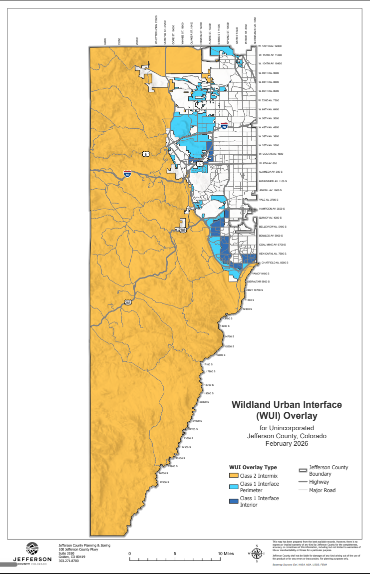
Jefferson County's WUI overlay map
Jefferson County publishes its own WUI overlay for unincorporated areas, split into Class 2 Intermix, Class 1 Interface Perimeter and Class 1 Interface Interior zones. If your home is in unincorporated Jeffco, this county overlay is the map your permit is judged against. The map below is the county's February 2026 version.
- Interactive Jefferson County WUI map
Zoom to your address on the county's official interactive WUI overlay map.
- WUI Overlay District map (PDF)
Download the February 2026 WUI overlay district map for unincorporated Jefferson County.
- WUI field tours and events
Upcoming Wildland Urban Interface recommendations field tours and county events.
Common questions
- How do I check if my address is in a WUI area?
- Look your address up on the Colorado Wildfire Risk Public Viewer and the 2025 Colorado Wildfire Resiliency Code Map, then call your county or town building department to confirm which map they adopted and what classification your parcel carries. The local map is what governs your permit.
- Is the wildfire code map the same as my insurance risk score?
- No. The code map decides whether building requirements apply. Insurance risk scores come from private models that carriers use for pricing and renewal. They are separate systems and often disagree about the same house.
- What if the map is wrong about my property?
- You can request a ground-truthing review under Section 304 of the code. It requires technical documentation from a qualified wildfire professional, and it evaluates fuels on and within 300 feet of your parcel, plus topography and fire behavior modeling.
Talk to us about your roof
We work out of 9822 Titan Park Cir, Littleton, and cover the Front Range foothills where this code matters most. Call (303) 738-1032 or book an inspection and we will confirm the local requirements, walk the roof, and put the 25% answer in writing with your estimate. Our neighborhood guides and service areas show where we work, and the insurance claim guide covers the documentation side.